Hero image featuring traffic.

Our Innovations

You can’t just flip a switch to get accurate parking information

Calculating where parking is available isn’t an easy task.  If it was easy, all the navigation apps would be routing us to available parking near our destination.

It’s not an easy task because detection and presentation of accurate parking information require domain-specific interpretation and inference. Raw data from real-time parking activity alone are not sufficient to calculate accurate parking availability because:

1

Data are not uniform.
Data from dedicated sensors display a range of characteristics that may change depending on factors such as temperature, time of day or nearby construction.

2

Data are often faulty.
Even data from sensors and cameras are imperfect and subject to interruption and latency in the network.

3

Data are only a proxy.
Data arising from associated or “proxy” activities such as payment are rarely 100 percent  aligned with actual parking behavior.

4

Data may be incomplete.
For example, data may be limited to a subset of parking spaces, blocks or areas.

Streetline overcomes these challenges through machine learning. In Streetline’s system, raw data are interpreted upstream by machine-learning algorithms that are developed from large amounts of historic data (including data from observation or “ground-truthing”), combined with relevant real-time parking events.  The final interpreted data sent to customer applications are therefore optimally accurate regardless of defects in underlying raw data.

For app users, data that are “sometimes” accurate are simply not good enough to satisfy motorists and ensure public support for smart parking initiatives.  Streetline’s machine-learning capabilities ensure that data are optimally accurate and usable at all times.

Vector image of grid

Machine-learning innovation is the key to providing high-quality availability data, even for situations with low or no dedicated sensing infrastructure

Leveraging 12 years of expertise, and a database of more than 720 million parking events, Streetline has designed an Open Inference Platform that provides the most accurate real-time parking availability based on accessible data.

Solutions Original
Modified Image

Products & Services

Parker

Parker is a free mobile guidance app for consumers that provides access to accurate real-time, parking availability and policy.

ParkerMap

ParkerMap enables customers to embed a real-time parking availability map on their website.

ParkSight

Parksight is a web-based tool that allows parking managers to conduct ad hoc analysis of parking data.

Guided Enforcement

Guided Enforcement is a mobile application that guides enforcement officers to time limit violations in real-time.

ParkEdge

ParkEdge is an easy-to-use self-publishing tool that enables public and private off-street parking operators to publish locations, rates, hours and availability in real-time.

FAST

FAST is a mobile app that enables the capture of parking policy and curb restrictions efficiently and accurately.

Guidance API

Guidance API provides real-time parking availability and policy on- and off-street.

Features

  • High-Resolution Modeling:  The Open Inference Platform trains a custom machine-learning model for each block to maximize data calculation accuracy.
  • Unsupervised Machine Learning:  The algorithm is generalized and does not need labelled datasets to adapt to new environments .
  • Resilient: The algorithm intelligently interprets incomplete or partial data for better overall utility and accuracy.
  • Versatile:  The algorithm combines different data sources in one platform to reduce the need for new  sensing infrastructure.
  • Continuous Accuracy Improvements: The detection results are filtered by probability and confidence level to minimize occurrence of false positives.
  • Sensing Technology Agnostic: Whether it’s existing technology infrastructure,  third party infrastructure or Streetline technology, our open platform consumes it all.

To access our real-time parking availability, parking demand and parking policy data visit: Developer Portal

Vector image of infra waves

Infrastructure-less sensing with minimal compromise to real-time parking availability or guidance accuracy

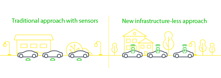
Streetline’s Parking Software Development Kit (Parking SDK) is a mobility innovation that enables accurate calculation of real-time parking availability and demand with little or no physical infrastructure.  Costs and infrastructure invasiveness are dramatically reduced with minimal impact on calculation accuracy.

The Parking SDK is a software library that may be embedded in a mobile app on most iOS and Android smartphones.  The SDK uses smartphone location and motion sensors to automatically and anonymously capture user parking activities in real time while operating in the phone’s background.  Streetline’s Open Inference Platform aggregates individual parking activities to calculate accurate, real-time parking availability and demand.

infrastructureless graphic

Features

  • No hardware to buy, install or maintain.
  • 100 percent anonymous – no personal  information is captured.
  • Identifies and reports parking arrival and departure events.
  • Provides Origin/Destination data for mobility and public transit planning.
  • Enhanced functionality and features for OEMs and mobility app partners which include greater than 90 percent availability accuracy and smart alerts  in existing apps, for example upcoming street sweeping, time limits, etc.
  • Low battery consumption.


Benefits

  • Lower cost.
  • Non-invasiveness.
  • Improved asset utilization.
  • Data-driven parking/curb policy, pricing  and planning.
  • Accelerated user adoption,  use and system confidence.

To integrate Streetline’s Parking SDK in your iOS and Android mobile apps, visit: Developer Portal

Vector image of dot radiating noise waves

In smart parking, one size doesn’t fit all.

With more than 12 years of operating experience, Streetline’s sensors — embedded and surface-mount — leverage machine learning to adapt to their environment continuously during their deployment.

Sensors
This allows high-accuracy even in the presence of environmental changes, including weather or nearby construction. As part of a continuous integration and test pipeline, sensor accuracy is assessed against a set of more than 10,000 audited ground-truth observations, assuring sensing accuracy in excess of 95 percent.

Cameras
Streetline’s camera-based sensing solutions use machine learning to identify real-time availability in on- or off-street locations, whether they are demarcated or undemarcated.  We can provide camera hardware or can leverage existing camera images without video streams, eliminating investment in new infrastructure. Our Open Inference Platform processes the camera images in real-time, on the edge or in our server, to provide parking availability and historical analytics — even in areas where cameras cannot reliably observe all spaces in a lot or on a given block.  Similar to sensors, a suite of audited ground-truth observations is used, assuring sensing accuracy in excess of 97 percent.

Vector image of gears

Needs and priorities vary greatly among customers and solution applications.

For that reason, Streetline technologies include tools to address a wide range of customer needs.

ParkSight

ParkSight is a trusted source for parking demand data on which our clients rely to build smart parking and smart transportation programs.  It is unique in the market, as the underlying source data are interpreted and processed by the Open Inference Platform’s machine learning to create the most accurate historical analytics.  While common analytics solutions capture and store the stream of real-time data, our approach leverages machine learning to realize the accuracy benefits of a retrospective look at the parking trends and store those in the analytics portal.


FAST

FAST is a mobile app that enables the capture of parking policy and curb restrictions efficiently and accurately.  Collection is easy and training is simple. Based on field research conducted by Streetline, FAST can produce more accurate results quickly, and at a lower cost, than approaches using lidar, 360 imagery, OCR/image transcription and satellite imaging.

When compared with these other approaches, FAST identified and processed three times more locations and did not commit the errors of other solutions, including missed disabled parking designations, miscategorized bicycle spaces, missed exclusions, “no parking” areas and loading zones.


Guided Enforcement

Guided Enforcement is a patented enforcement tool that provides 99.5 percent accuracy in identifying time-limit violations.  Guided Enforcement is designed to be crowd-sourced so that deployed enforcement officers efficiently issue expired meter and time-limit citations without duplication or beat overlaps.  Guided Enforcement is provided only for Streetline deployments using 100 percent sensor coverage.


ParkEdge

Parkedge is a web portal that allows off-street parking facilities to provide location, availability and policy information to consumers in real-time. This information is blended with on-street parking information and made available via the Guidance API, Parker and ParkerMap.